
AG SERVICES
THE FUTURE OF FARMING
Drones are changing the game for farmers, bringing a new level of precision and efficiency to agriculture. Read further to find out how ARC Drone Solutions can assist with your farming or ranching operation.
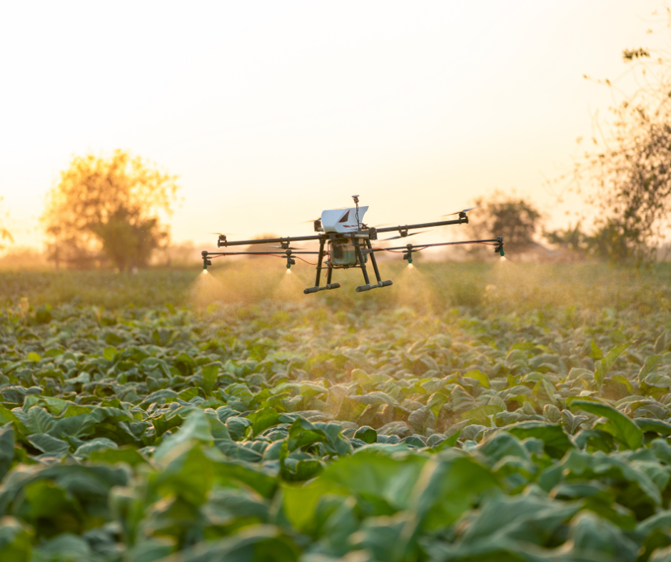
Aerial Spray Application
Modern drone technology supports precision agriculture, optimizing spray application to improve crop yields and sustainability.
The DJI T50 features an integrated spraying system that can be used to apply fertilizers, pesticides, or herbicides precisely where needed. The drone's advanced GPS, RTK and mapping systems allow it to follow pre-set flight paths and deliver accurate spray coverage to the edge of the field.
Benefits: Precision spraying reduces chemical waste, lowers operational costs, and minimizes the risk of over-spraying. It also improves crop safety by targeting only the areas that need treatment, reducing harm to surrounding plants and the environment.
Use Cases:
Applying to fungicide to disease infected fields, particularly in wet environments
Spraying soybeans with pesticide to combat aphids
Targeting spraying weeds with herbicide (fields, pastures, ditches)
Applying foliar to improve plant health and encourage growth
Treating livestock herds with fly and tick spray
Aerial Dispersion
The DJI T50 is a specialized agricultural drone designed to assist in aerial dispersion of various agricultural products, including seeds, dry fertilizer, and other granular materials.
The T50 is equipped with a granular spreader system that can efficiently disperse products like seeds, fertilizers, and herbicides. The spreader uses a combination of rotors and airflow to distribute the granular materials evenly over a wide area. This ensures that products are spread in a consistent pattern, which is crucial for crop growth and effective application of fertilizers.
Use Case:
Seeding cover crop from the air
Spot spread granular fertilizer in underperforming areas
Plant Health Assessments & APPLICATION PERSCRIPTIONS
Unmanned aerial vehicles (UAVs) allow for precise, real-time data collection, enabling farmers to monitor plant health, detect pest infestations, and assess soil conditions with unprecedented accuracy.
The DJI T50 is equipped with multispectral sensors that can capture images in different wavelengths of light, allowing farmers to assess the health of their crops. This technology helps detect issues like nutrient deficiencies, pest infestations, or disease outbreaks before they become visible to the naked eye.
Benefits: Early detection allows farmers to take proactive measures, such as applying fertilizers or pesticides only where needed, reducing input costs and minimizing environmental impact. It also helps ensure healthier crops and higher yields.
Use Cases:
Assess plant nutrition through multispectral analysis, prescription for variable rate fertilizer
Detect presence of fungal disease in corn, prescription for fungicide treatment
Check soybeans for aphid infestations, prescription for pesticide application
FIELD, Pasture, & Property MAPPING
With its advanced imaging, sensors and navigation systems, the DJI T50 can create detailed, high-resolution maps of agricultural fields. These maps highlight areas of concern such as dry spots, low vegetation, or uneven growth patterns, providing valuable insights for farmers to take targeted actions.
Benefits: These maps help farmers make more informed decisions about where to focus their resources. By identifying potential problem areas early, farmers can implement targeted irrigation, fertilization, and pest control strategies, leading to better resource management and improved crop yields.
Use Cases:
Monitor soil moisture levels and drainage for tile mapping or irrigation management
3D elevation mapping to identify or monitor erosion and compaction
Identify and map locations of field rocks for efficient removal
3D modeling and measurements of terrain, buildings, property lines, etc.
Building & Property INSPECTIONS
Equipped with multispectral sensors and HD cameras, drones can create detailed maps that highlight areas in need of attention, reducing the need for manual inspections. Drones can provide detailed visuals for maintenance checks, damage detection, and assessments of structural integrity.
Use Cases:
Inspection of grain complexes and large outbuildings for possible storm damage
Inspection of fence lines and pasture for hazards, weeds, and forage quality
Inspection of irrigation lines and pivots for leaks, clogging, wear and tear
Inspection of fields for crop damage (fires, wind, hail, escaped cattle, insect infestation, drought, flooding, chemical burns)
Imaging & Aerial Photography
While the T50’s primary focus is not traditional aerial photography or videography, its capabilities can be leveraged for advanced agricultural imaging.
The T50 can capture or live stream high-definition video footage during flight, which can be used for various purposes, such as monitoring crops or providing visual records of farm conditions.
Use Cases:
Aerial Photography: Aerial photos or videos of farmstead, fields or pastures. Photos of inventory and stockpiles. Monitor progress of remote construction projects.
Thermal Imaging: Detect hot spots on equipment, electrical wiring, bins, hay and silage, evaluate thermal efficiency of buildings, locating lost animals

“It all begins with an idea. Maybe you want to launch a business. Maybe you want to turn a hobby into something more. Or maybe you have a creative project to share with the world. Whatever it is, the way you tell your story online can make all the difference.”
— Squarespace